Key takeaways
- UAV Imaging exhibited at the Federation of Alberta Gas Co-ops tradeshow on November 27-28th, 2023.
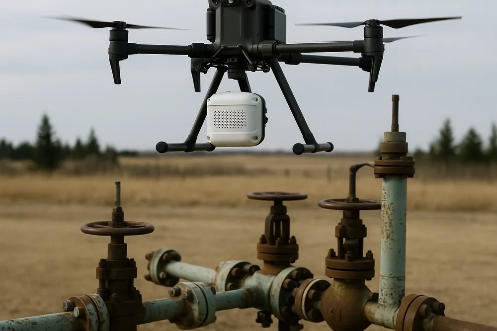
- The booth showcased our drone-based Methane Gas Detection service for Alberta gas infrastructure.
- Aerial methane screening covers far more ground per day than a ground-crew walkdown.
Visit Our Booth
UAV Imaging is attending the Federation of Alberta Gas Co-ops tradeshow November 27-28th, 2023.
Swing by our booth to learn more about our Methane Gas Detection service.
8-12 kmAerial methane survey covers 8-12 km per flight hour, versus 1-2 km per ground-crew day — a screening tool that catches leaks worth a closer ground walkdown.
Learn More About Alberta Gas Co-Ops
Frequently Asked Questions
What did UAV Imaging demonstrate at the Federation of Alberta Gas Co-ops tradeshow?
A working demonstration of aerial methane detection using the Pergam Falcon laser sensor mounted on a Matrice 300 RTK, covering distribution lines and small-pad gas infrastructure relevant to rural Alberta gas co-ops.
How sensitive is aerial methane detection compared to a ground survey?
The Pergam Falcon detects methane plumes down to roughly 5 ppm-m. Aerial survey covers 8-12 km per flight hour versus 1-2 km per ground crew day, making it a screening tool that catches leaks worth a closer ground walkdown.
Does aerial methane detection satisfy Directive 060 reporting requirements?
It is accepted as a screening method under Directive 060 when paired with a Method 21 ground walkdown of any positive detections. The aerial flight produces geo-tagged sensor data; the walkdown classifies leaks for repair tracking.
Are aerial methane surveys cost-effective for small distribution co-ops?
Yes. A single survey day covers the equivalent of several days of ground crew work and produces a documented digital record. Most co-ops run an annual or semi-annual aerial sweep on top of their existing ground walks.
Book a drone methane detection survey
Aerial methane screening across Alberta — fast coverage, geo-tagged sensor data, Directive 060-ready when paired with a ground walkdown.
Request a quote →
or call 587-532-9000