UAV Imaging covers Lethbridge and southern Alberta with a drone-services menu built around the region's defining industries: irrigated agriculture, renewable energy, food and beverage processing, and the construction and aggregate work that supports them. Crews dispatch from Edmonton and stage multi-day deployments out of Lethbridge for larger scopes.
Services available in Lethbridge
- Precision-ag & irrigation mapping — multispectral crop-health (NDVI) scouting, pivot and drainage planning, field orthomosaics for the irrigated-acreage operators across the St. Mary River (SMRID), Taber (TID) and Raymond (RID) irrigation districts that define the Lethbridge County economy
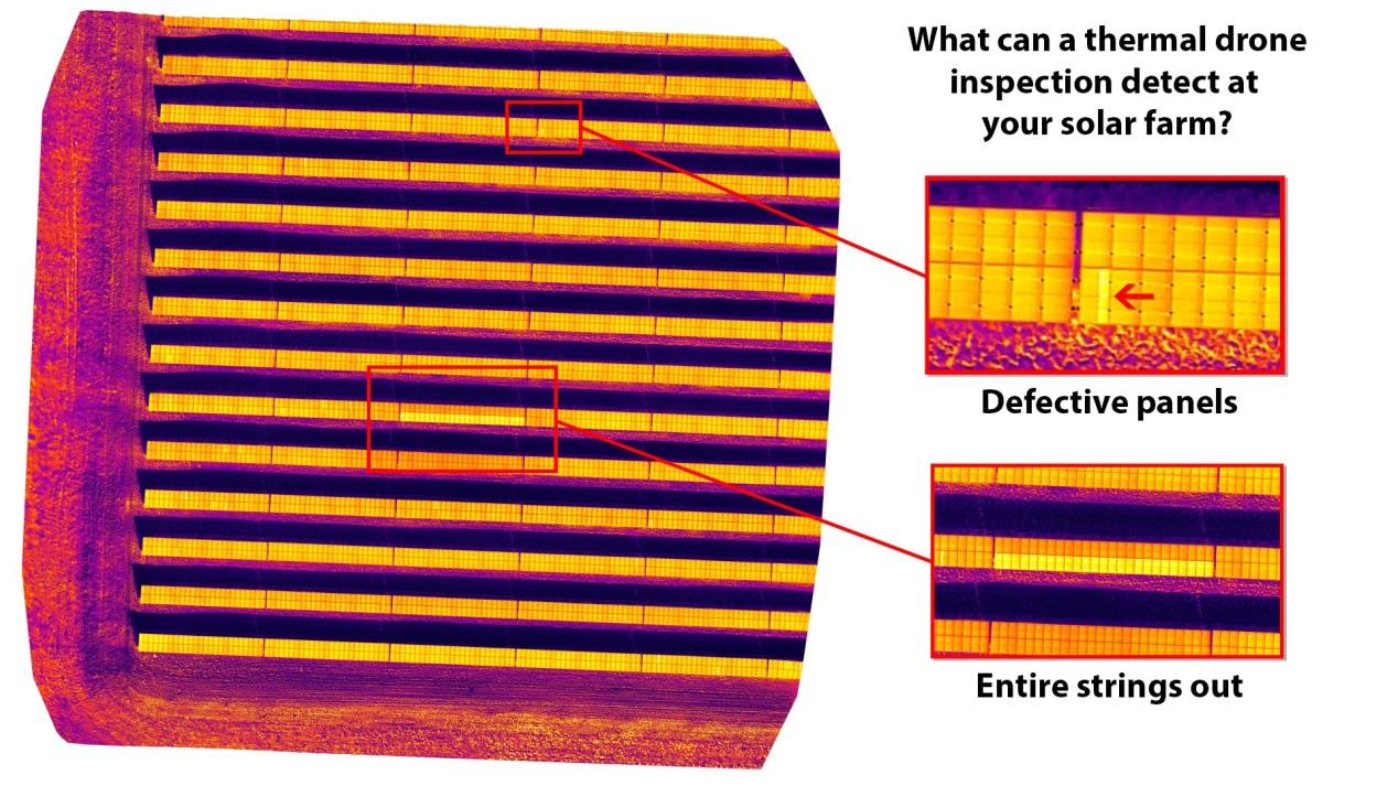
- Solar-farm thermal inspection — every-module radiometric scan and severity-ranked anomaly reporting for southern Alberta's utility-scale arrays
- Drone inspection services — wind-turbine blades, powerlines and transmission, structural steel and food-processing facilities
- Drone construction services — site progress, as-built mapping, earthworks volumes
- Drone mapping & pit plans — gravel-pit volumes, bench geometry, reclamation documentation
Industries served around Lethbridge
- Agriculture & irrigation — precision-ag scouting, NDVI health mapping, drainage and pivot planning across the St. Mary River, Taber and Raymond irrigation districts
- Renewable energy — solar-array thermal inspection, wind-turbine blade inspection across the wind-and-solar corridor of southern Alberta
- Food & beverage processing — facility roof, structural and thermal inspection
- Construction & heavy civil — progress photography, as-built mapping, earthworks volumes
- Aggregate & gravel — pit volumes, bench mapping, reclamation
Service area
UAV Imaging works Lethbridge proper and the surrounding southern communities — Coaldale, Coalhurst, Picture Butte, Nobleford, Taber, Vauxhall, Raymond, Magrath, Fort Macleod and Cardston — plus the irrigation districts and the wind-and-solar sites across the southern grid. Edmonton-based dispatch with multi-day Lethbridge staging for larger scopes.
Why hire a drone operator familiar with southern Alberta work
Southern Alberta combines the province's most intensive irrigated agriculture with its densest renewable-energy buildout — and the Chinook wind that complicates both. Solar thermal work needs the right irradiance window; wind-turbine inspection needs calm-wind scheduling; ag mapping needs the right growth stage. UAV Imaging plans around those windows and arrives with the fleet (Matrice 300 RTK + H20T radiometric thermal + multispectral + LiDAR) and the certifications the work demands.
Compliance and credentials
- Transport Canada Advanced RPAS certified pilots on every flight
- $5M aviation liability insurance (above the 2026 $2M minimum)
- ISN, ComplyWorks, Avetta registered
- Site-Specific Operations Risk Assessment (SORA) on higher-risk operations (utility-scale arrays near transmission)
- 2026 Remote ID compliant fleet