How aerial thermal supercharges your ground crews
A drone scan isn't a replacement for your ground crews, it's what makes them efficient. One flight gives you a bird's-eye view of the entire farm and surfaces the problem areas, so you can dispatch crews straight to the panels that need attention instead of walking every row.
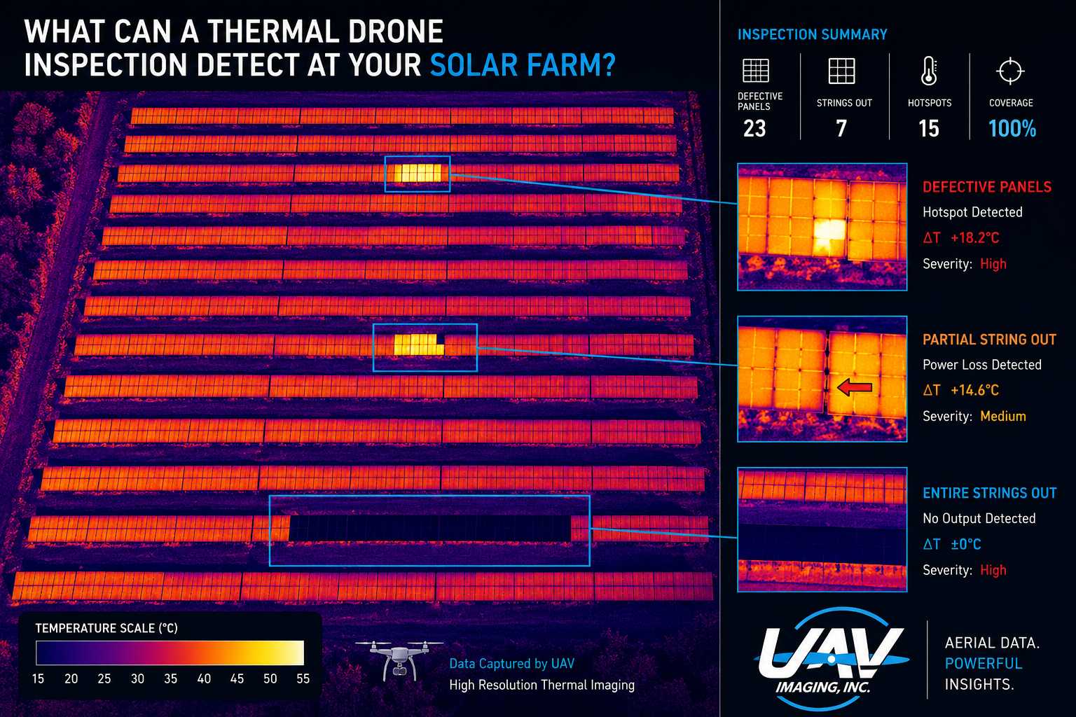
Fast fault map
A single flight maps your whole array and hands back a fault map: exactly where the problem panels are. Your crew skips the row-by-row hunt and goes straight to the location.
Complete
Every module imaged, not a sample. Radiometric thermal + RGB overlay means nothing hides between rows.
Precise
Every flagged panel is pinned to its exact location on a geo-referenced thermal map. Your crew sees precisely where to go, visually, before they set foot on site.
Whole-site view
One mosaic map of the entire array gives your team a single bird's-eye reference for every defective module across the site.
What we can detect
- Failed / underperforming strings
- Cell-level hotspots
- Bypass-diode failures
- Cracked & shattered modules
- PID degradation
- Soiling & shading
- Vegetation encroachment
- Combiner / connector faults
How we work
Every flight is run inside the high-irradiance, low-wind window where thermal anomalies show clean contrast. We log irradiance, ambient temperature, wind speed, equipment and operator on every job, so the scan is reproducible and defensible.
Radiometric hardware
Thermal sensors with sub-50 mK sensitivity (NETD), flown at altitudes that resolve every module to multiple pixels. Radiometric output means we measure absolute temperature, not just relative contrast — the difference between "looks warm" and "this string is down".
Every module imaged
No sampling, no walking rows with a handheld FLIR. A single flight covers the entire array. You see what's actually happening on roof-pitch and interior rows that ground crews physically can't reach.
Module-level mapping
Each flagged anomaly is geo-tagged to the individual module and dropped onto a thermal mosaic map, so your crew can locate every problem panel without hunting.
Annual portfolio scan
One mobilization across your full AB / SK portfolio. Year-over-year radiometric comparison shows degradation trends, lets you triage capex against actual generation loss rather than guesswork.
What you receive
- Radiometric GeoTIFF — full-array thermal orthomosaic, importable into QGIS / ArcGIS.
- RGB orthomosaic — high-res visual overlay for context.
- Thermal mosaic map — every module-level defect pinned to its location across the site.
- Flight conditions log — irradiance, temperature, wind, equipment, operator. Audit-trail grade.
Delivered within 3-5 business days of the flight. We customize the deliverables to fit your team's workflow, tell us what your O&M process needs and we'll shape the output to match.
Serving solar across Alberta & Saskatchewan
From utility-scale arrays in Vulcan, Newell and Forty Mile counties to commercial rooftop systems in Edmonton, Calgary and Saskatoon. Crews mobilize anywhere in Alberta and into western and east-central Saskatchewan. Travel built into the quote up front.