Drone LiDAR and drone photogrammetry both produce a 3D point cloud and a measurable surface model, but they get there by completely different physics — and that difference decides which one is right for your site. UAV Imaging flies both, and picks the method as a pre-flight planning decision based on the site and the deliverable, not a sales preference. This page sets out the honest tradeoffs.
How each method works
Photogrammetry reconstructs geometry from overlapping 2D photographs. It needs visible surface and adequate light and texture for the software to match features between images. LiDAR (Light Detection And Ranging) fires hundreds of thousands of laser pulses per second and measures the return time of each — the geometry comes from pulse timing, not from images, so it provides its own illumination and can find the ground through gaps in vegetation.
LiDAR vs photogrammetry at a glance
| Dimension | Drone LiDAR | Drone Photogrammetry |
|---|---|---|
| Sensing principle | Active laser ranging (pulse return time) | Passive imagery (feature matching across photos) |
| Vegetation | Penetrates canopy, returns bare-earth ground | Sees only the top of the canopy |
| Light dependence | Works in low light and shadow | Needs good light, sun angle and surface texture |
| Typical horizontal accuracy | 3-6 cm with RTK/PPK GNSS | 2-5 cm with good GCP control |
| Typical vertical accuracy | 3-8 cm | 4-10 cm (degrades on low-texture or shadowed ground) |
| Linear features (wires, edges) | Resolves thin wires and hard edges well | Struggles with thin wires and uniform surfaces |
| Visual deliverable | Point cloud only (no true-colour image unless paired) | Produces the orthomosaic image as a primary output |
| Typical point density | 100-500 pts/m² at survey altitude (higher on slow, low flights) | Set by GSD; very dense on visible surface, none under cover |
| Ground control needed | RTK/PPK; few or no GCPs on controlled sites | RTK plus distributed GCPs for engineering accuracy |
| Occlusion / under-structure | Finds gaps; reaches ground through canopy | Sees only what the camera sees |
| Eye-safety | Class 1 eye-safe laser; standoff still planned | Passive camera; no laser exposure |
| Relative cost | Higher (payload + processing) | 30-60% the cost of an equivalent LiDAR deliverable |

When LiDAR is the right tool
- Vegetated sites — forestry, pipeline and powerline ROW, transmission corridors, parks and natural areas where you need bare-earth ground under canopy
- Low-light or shadow-heavy environments — deep open pits, canyon and high-wall faces, north-facing winter slopes
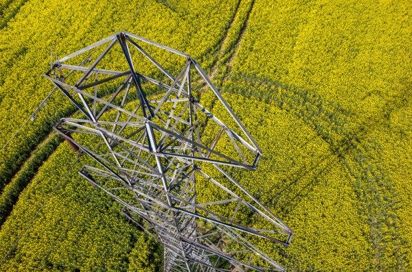
- Powerline and structural inspection — LiDAR resolves wires and small linear features photogrammetry misses
- High-rigour engineering — where independent geometry redundancy is preferred
When photogrammetry is the right tool
- Open-air sites with good light — aggregate yards, construction sites, urban survey with adequate surface texture
- When the deliverable is the image — the orthomosaic itself is the product (progress photos, visual documentation)
- Cost-sensitive and recurring work — monthly stockpile cycles where the geometry is open, repeatable and unobstructed
- Crop and field mapping — multispectral NDVI work is photogrammetry-based by nature
Alberta conditions that swing the choice
Alberta's terrain and seasons push the decision more than the brochure specs do. A few realities we plan around:
- Boreal and aspen canopy (forestry, pipeline and powerline ROW north of the prairie) is the classic LiDAR case — photogrammetry cannot see the ground through it.
- Leaf-on vs leaf-off. Late-fall and early-spring leaf-off flights improve both methods over vegetation, and on marginal canopy can let photogrammetry reach ground it could not in summer.
- Winter low sun and snow cover degrade photogrammetry (long shadows, low texture on uniform snow); LiDAR is far less affected because it provides its own illumination.
- Foothills and high-wall relief create deep shadow that favours LiDAR; flat open prairie and aggregate yards favour photogrammetry.
Deliverable formats from either method
- LiDAR: classified point cloud (LAS / LAZ), bare-earth DTM, DSM, contours (DXF / LandXML), and a paired orthomosaic when the mapping camera flies alongside
- Photogrammetry: orthomosaic (GeoTIFF), dense point cloud, DSM, contours, and 3D textured mesh
- Both: accuracy report with check-point residuals and flight conditions; CAD-ready surfaces (DXF / LandXML) in the coordinate system the design platform expects
The blended deliverable
On larger projects the increasingly common answer is "both": photogrammetry for the bulk open surface and the orthomosaic, LiDAR for the vegetated patches and linear features, ground survey for the structural detail. The point cloud and orthomosaic from each method are merged in post-processing into a single deliverable. The right question is rarely "LiDAR or photogrammetry?" in the abstract — it is "what does this site and this deliverable need?"
Fleet & sensors we fly for survey
Both methods fly on the same workhorse aircraft, so the choice is a payload swap, not a different program:
- DJI Matrice 300 RTK — primary survey platform, RTK GNSS, dual-payload bay, ~55-min endurance, -20°C rated
- LiDAR payload — integrated GNSS/IMU for direct georeferencing; vegetation penetration and linear-feature capture
- Mapping camera — high-MP full-frame for photogrammetry orthomosaics and dense point clouds
- Multispectral — for crop and vegetation index mapping (photogrammetry-based)
- RTK base / PPK workflow — centimetre-grade control with independent check points on engineering deliverables
Processing runs in Pix4D and Agisoft Metashape with QGIS/ArcGIS deliverable prep; every engineering job ships with an accuracy report documenting check-point residuals and flight conditions.
Compliance in Alberta airspace
Either method flies under the same compliance footprint. Transport Canada Advanced RPAS certified pilots on every mission; NAV Drone authorization for controlled airspace (including the Calgary CYYC and Edmonton CYEG control zones) and RPAS Flight Authorization where required; $5M aviation liability above the 2026 $2M minimum; ISN, ComplyWorks and Avetta registrations current for industrial and energy site access; SORA produced on higher-risk operations.
Where we fly & what we map
UAV Imaging runs both LiDAR and photogrammetry across Alberta — oil & gas (gathering and ROW), aggregate and mining, agriculture, forestry, solar, construction and utilities — staging from Edmonton with multi-day deployments to Fort McMurray, Grande Prairie, Lethbridge and the rest of the province. See mapping & pit plans and stockpile measurement for the service detail.
How UAV Imaging chooses
The Matrice 300 RTK carries both a LiDAR payload and the standard mapping camera on its dual-payload bay. UAV Imaging deploys LiDAR for vegetation-heavy mapping (forestry, ROW, pipeline corridor), powerline and transmission inspection, and high-rigour engineering deliverables; photogrammetry is the default for open-site aggregate, construction, urban survey and ag mapping. The method is chosen at the planning stage for each site — and on the right project, both fly together.